
PASAJES Librería internacional: su libro en español, inglés, francés, alemán, italiano, portugués o del idioma que busque en casa.
Usted se encuentra en:
Inicio
/ Libros
/ INGLÉS / Viajes, gastronomía y geografía / Geografía y cartografía /
Menú principal
Acceso a clientes
Mi pedido:
Mi pedido
0 artículos
0,00 €
-
Escapology
Modern Cabins, Cottages and Retreats
Sin ejemplares (se puede encargar)
-
Spain And Portugal 2024
Tourist And Motoring Atlas
- Michelin, 2024
Libro encuadernado en tapa blanda
PVP: 22,00 €
ISBN 978-2-06-726152-5
EAN 9782067261525
Sin ejemplares (se puede encargar)
-
- Lonely Planet, 2023
Libro encuadernado en tapa blanda · 2 páginas
PVP: 11,00 €
ISBN 978-1-78701-710-8
EAN 9781787017108
Durable and waterproof, with a handy slipcase and an easy-fold format, Lonely Planet's Madrid City Map is your conveniently sized passport to travelling with ease. Get more from your map and your trip with images and information about top city attractions, walking tour routes, transport maps, itinerary suggestions, an extensive street and site index, and ...
más informaciónSin ejemplares (se puede encargar)
-
Durable and waterproof, with a handy slipcase and an easy-fold format, Lonely Planet's Berlin City Map is your conveniently sized passport to travelling with ease. Get more from your map and your trip with images and information about top city attractions, walking tour routes, transport maps, itinerary suggestions, an extensive street and site index, and ...
más informaciónSin ejemplares (se puede encargar)
-
Sin ejemplares (se puede encargar)
-
- Granta Books, 2021
Libro encuadernado en tapa blanda · 232 páginas
PVP: 20,65 €
ISBN 978-1-84627-663-7
EAN 9781846276637
WITH A FOREWORD BY TIM HARFORDWhich nations have North Korean embassies? Which region has the highest number of death metal bands per capita? How many countries have bigger economies than California? Who drives on the 'wrong' side of the road? And where can you find lions in the wild?Revelatory, thought-provoking and fun, Brilliant Maps is ...
más informaciónSin ejemplares (avisar cuando esté disponible)
-
Sin ejemplares (encargos sólo en librería)
-
National Geographic Family Reference Atlas
5th Edition
Libro encuadernado en tapa dura · 400 páginas
PVP: 88,25 €
ISBN 978-1-4262-2144-6
EAN 9781426221446
Show your kids the world with fascinating facts and more than 650 photographs, maps, and graphics covering every country--plus the poles, the oceans, and outer space--in this completely revised edition of National Geographic's beloved family-oriented atlas. This exquisitely updated edition of National Geographic's popular and reader-friendly Family Reference Atlas features authoritative maps, detailed artwork, and ...
más informaciónSin ejemplares (se puede encargar)
-
- The British Library, 2020
Libro encuadernado en tapa blanda · 272 páginas
PVP: 25,85 €
ISBN 978-0-7123-5332-8
EAN 9780712353328
Originally published in hardback, Atlas: A World of Maps from the British Library is now available in paperback. This is an atlas with a difference. Few of the maps in this book could reasonably be called accurate in the modern sense and could almost certainly not be used to plan a journey. Yet this atlas ...
más informaciónSin ejemplares (se puede encargar)
-
The History of Cartography
Cartography in the European Enlightenment : 4
Libro encuadernado en tapa dura · 1920 páginas
PVP: 525,85 €
ISBN 978-0-226-18475-3
EAN 9780226184753
Since its launch in 1987, the History of Cartography series has garnered critical acclaim and sparked a new generation of interdisciplinary scholarship. Cartography in the European Enlightenment, the highly anticipated fourth volume, offers a comprehensive overview of the cartographic practices of Europeans, Russians, and the Ottomans, both at home and in overseas territories, from 1650 ...
más informaciónSin ejemplares (encargos sólo en librería)
-
- Lonely Planet Kids, 2019
Libro encuadernado en tapa dura · 304 páginas
PVP: 28,95 €
ISBN 978-1-78868-130-8
EAN 9781788681308
Experience 60 of the world's greatest adventures on water - from sailing the Nile by felucca and cruising the Canadian Arctic, to exploring Pitcairn Island by cargo ship. With detailed accounts of each route, beautiful photos and practical tips on how to plan your own voyage, Amazing Boat Journeys will help you discover a more ...
más informaciónSin ejemplares (se puede encargar)
-
Sin ejemplares (se puede encargar)
-
- Arcturus Publishing Ltd, 2018
Libro encuadernado en tapa blanda · 192 páginas
PVP: 20,30 €
ISBN 978-1-78404-843-3
EAN 9781784048433
Sin ejemplares (se puede encargar)
-

- Collins (Uk), 2017
Libro encuadernado en tapa blanda
PVP: 17,55 €
ISBN 978-0-00-826251-8
EAN 9780008262518
Up-to-date A4 spiral bound road atlas of Europe. Contains clear, detailed road mapping, perfect for touring the Mediterranean, Iberian peninsula, Scandinavia and many other European tourist destinations. Scale of main maps 1:1,000,000 (1 cm to 10 km / 1 inch to 16 miles).MAIN FEATURESClear, easy to follow road maps at a scale of 1:1,000,000. Euroroutes ...
más informaciónSin ejemplares (se puede encargar)
-
Libro · 960 páginas
PVP: 35,90 €
ISBN 978-1-78657-653-8
EAN 9781786576538
We've taken the highlights from the world's best guidebooks and put them together into one 960-page whopper to create the ultimate guide to Earth. User-friendly, in A-Z format, this guide gives a flavour of each country in the world, including a map, travel highlights, info on where to go and how to get around, as ...
más informaciónSin ejemplares (se puede encargar)
-
- Könemann, 2017
Libro encuadernado en tapa blanda · 320 páginas
PVP: 19,95 €
ISBN 978-3-7419-1980-0
EAN 9783741919800
Sin ejemplares (se puede encargar)
-
- Collins (Uk), 2017
Libro encuadernado en tapa dura · 144 páginas
PVP: 27,00 €
ISBN 978-0-00-825305-9
EAN 9780008253059
Discover the most intriguing, fascinating and extraordinary facts about the world in this lavishly illustrated, large format atlas. Feed your imagination and go on an adventure with this unusual atlas which is illustrated with a wealth of quirky facts and curiosities from around the world. Uncover hidden secrets on every page - from world cultures ...
más informaciónSin ejemplares (se puede encargar)
-
- Collins (Uk), 2017
Libro encuadernado en tapa blanda · 224 páginas
PVP: 9,45 €
ISBN 978-0-00-825111-6
EAN 9780008251116
A pocket-sized guide to nearly 140 of Scotland's most dramatic castles and strongholds, all of which are open to the public. Historical background and architectural details for each of the castles, accompanied by a beautiful colour photograph. Includes the major sites of Edinburgh and Stirling, and covers from as far north as Shetland (Muness) to ...
más informaciónSin ejemplares (se puede encargar)
-
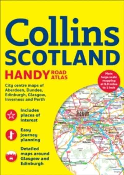
- Collins (Uk), 2017
Libro encuadernado en tapa blanda · 72 páginas
PVP: 6,75 €
ISBN 978-0-00-823275-7
EAN 9780008232757
This easy-to-use, handy A5 sized road atlas is your ideal companion for navigating around Scotland. It has extremely clear, route planning maps of Scotland, detailed city plans of the major cities and towns and fits neatly into your glovebox or briefcase or bag. MAIN FEATURESClear, attractive route planning maps of the whole of Scotland supported ...
más informaciónSin ejemplares (se puede encargar)
-
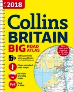
- Collins (Uk), 2017
Libro encuadernado en espiral · 176 páginas
PVP: 16,20 €
ISBN 978-0-00-821455-5
EAN 9780008214555
The ultimate 3.2 miles to 1 inch scale A3 spiral bound road atlas of Britain for 2018, featuring Collins' popular and well-established road mapping. Designed for exceptional clarity and ease of use. This fully updated road atlas covers the whole of Britain with each scale of mapping colour-coded for ease of use.The smallest scale maps ...
más informaciónSin ejemplares (se puede encargar)